As reported in August in this blog,
Boko Haram, the extremist Islamist terrorist group in
Nigeria which has been waging a lethal war against Christian (and other) civilians for years, took a page from the
Islamic State (
I.S.) and
al-Qaeda playbook and declared a separate Islamic “caliphate” in northern Nigeria. But now the contours of that nascent state are coming into sharper focus. Last week, Boko Haram renamed Mubi, a city of over 100,000 people in
Adamawa State, near the border with
Cameroon, which the group had recently taken control of. It is now, they say, “Madinatul Islam,” which means “City of Islam,” and presumably it is the capital of this kernel of a new Islamic nation.
![]() |
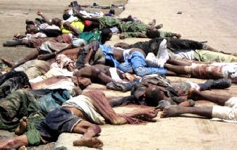
The city of Mubi after Boko Haram paid it a visit about a year ago. Now it controls it completely. |
|
Boko Haram, according to news reports,
controls four of Adamawa’s twelve local government areas (L.G.A.s)—as subdivisions of Nigerian states are called. These L.G.A.s are all adjacent and bunched in the northern tip of Adamawa. They are Madagali, Michika, Mubi North, and Mubi South—including, of course, the city of Mubi. Boko Haram roadblocks and checkpoints have been set up along the borders of the quasi-statelet, and the Nigerian government and military have no presence there. The group has announced its aim to take over all of Adamawa, a state of nearly 4 million people roughly the size of
Maryland or
Taiwan.
![]() |
In this map, Borno State local government areas
controlled by Boko Haram are circled in red. |
Already, Boko Haram
was reported to control an astounding one-third of the twenty-four L.G.A.s in
Borno State. Borno is the much larger and more populous state to the north of Adamawa where Nigeria,
Chad,
Niger, and Cameroon meet at Lake Chad. It is here, in late August, that Boko Haram declared the city of Gwoza, which it had captured, to be the kernel of the new caliphate. It also at that time already controlled Gulak, in the current northern-Adamawa statelet, and a string of towns spilling across southern Borno into
Yobe State as well. Borno, with over 5 million people, is about the size of
Ireland. In addition to Gwoza, then, Boko Haram now also controls the Borno L.G.A.s of Gamboru-Ngala, Kala-Balge, Marte, Dikwa, Bama, and Askira-Uba, as well as part of Konduga (see map above). Observers expect the group to make a grab soon for Maiduguri, the Borno capital, which has over 1 million people and which is already nearly surrounded by Boko Haram territories.
One wonders if that is the point at which Nigeria will bring the full force of its military to combat the Boko Haram threat, or the point at which the international community will regard what is happening in northern Nigeria as a crisis as serious as that in
Iraq and
Syria with Islamic State.
![]() |
| Every northern Nigerian’s nightmare is to wake up in the morning and see something like this roll into town. |
[For those who are wondering, yes, this blog is tied in with my new book, a sort of encyclopedic atlas just published by Litwin Books under the title Let’s Split! A Complete Guide to Separatist Movements and Aspirant Nations, from Abkhazia to Zanzibar. (That is shorter than the previous working title.) The book, which contains 46 maps and 554 flags (or, more accurately, 554 flag images), is available for order now on Amazon. Meanwhile, please “like” the book (even though you haven’t read it yet) on Facebook and see this special announcement for more information on the book.]


